Stories Covering " ISLANDS "


LATEST TOWN STORIES


Showing posts with label ISLANDS. Show all posts

Some netizens liked, commented, and shared this. Share your comment. Mag-reply ako once mabasa ko.
Stories of town explorations.
"Starfish may look so cute but actually, they are predators and they eat other live marine organisms. So, some marine species must have the reason to be afraid with this starfish I am handling."

This island is super star-studded! You can see here the most beautiful stars and this stars are so alive! I am referring to the stars of the sea. Guess what? They are the starfish!
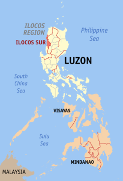
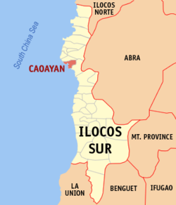
Maps by Wikipedia
Location Highlighted in Red
In my previous post "Pinget Island: The Island with No Identity," I promised you that I will be featuring a discovery of mine and this discovery is about the wildlife underwater concerning the starfishes of this island.

Although this has been an old discovery of mine since it's been about 5 years the last time I touched these marine organisms, I still want to share it with you now that I have an opportunity. Let's begin!

The Eastern coast of Pinget Island in the town of Magsingal in Ilocos Sur province, Philippines is facing the pristine Lapog Bay. Lapog Bay is in fact a favorite destination for fishermen because of it's rich marine resources.

This bay supports a diverse form of marine species that has chosen this bay to be their home and one proof of this is the abundance of a starfish species, specifically at Pinget island.

In the world, there are1,800 living species [that's many!] of starfish that occur in all the world's oceans, including the Atlantic, Pacific, Indian as well as in the Arctic and the Southern Ocean (i.e., Antarctic) region. They are also called "sea stars" or generally called as the echinoderms. According to experts, more species are waiting to be discovered

Did you know that a starfish eats too? Well, of course, but where is the mouth, the esophagus and the stomach or, do they have those organs? The answer is yes. They have those organs. They also have anus to excrete their waste! Their mouth is located underside their body.


Starfish may look so cute but actually, they are predators and they eat other live marine organisms. So, some marine species must have the reason to be afraid with this starfish I am handling.

Any idea about the life span? Well, starfish life span depends upon the species. Some may live about 10 years and some can reach up to more than 30 years.

Do they breathe? Yes of course, they are animals too. If you try to notice them [if ever you've seen one], there are tiny structures [called papullae]  that dot their surfaces and these structures are the gateway for their respiration.

Starfish carries a big role in the balance of the ecosystem. So let's take care of their natural habitat. Sea stars and other echinoderms pump water directly into their bodies, via the water vascular system, as they find it. This makes them vulnerable to all forms of water pollution, as they have little ability to filter the water of toxins and contaminants. Oil spills and similar events often take a toll on echinoderm populations that carry consequences for the ecosystem [Oh no!  Let's don't let that happen]

Now guys I hope you enjoyed this post once again and if it is corny, please forgive me! Hehe. By the way, I need your feedback, comments and suggestions so that I can give you my best shot! Hehe... And you can suggest to me things, events, people or anything under the sun that you want me to feature here and I will try my best to feature it as long as I have the resources and time! You can suggest them below through the comment box or email me at edmaration@gmail.com.
NAGUSTUAM DIAY NABASAM/NAKITAM? MABALIN MO MET I-LIKE.

Some netizens liked, commented, and shared this. Share your comment. Mag-reply ako once mabasa ko.
Stories of town explorations.
"It is also popular as the home of smuggled motor vehicles, electronic gadgets, bicycles and other electronic items making it's residents a home-grown businessmen..."

As an aspiring investigative/travel journalist and a TV Documentary Host "wanna be," it makes me so insomniac every night without searching for the reason why this place is called an island which in fact, I didn't see any island when I first visited this place. I need to taper down the anxiety of curiosity. It's weird because when I visited this island the first time,I never crossed a bridge spanning the sea or ride in a boat to reach this so called island. Meaning, this land mass is not detached, so it is not an island.


Maps by Wikipedia
Location Highlighted in Red
Thanks to the residents of this island I have interviewed including the media on which I gathered an analysis. Now, I have discovered the reason why! Let's begin...

During low tide and most of the time, this island is not actually an island. It turns to be a peninsula geographically speaking. But when the high tide and when the rain comes, the sea at East and the West coasts of the island meet together, thus, submerging the narrow strip of land that connects it to the mainland making it technically an island. Interesting isn't it?

With this interesting feature, it makes Pinget Island a unique island and a peninsula in one. It has two geographical classifications, an island and a peninsula which is a very rare scenario in the world!

Please do try to analyze the map below so that you can appreciate the interesting feature of this island and then read my explanation below.


There you have the map of Pinget island. Please take note that this island tend not to be totally detached from the mainland. 

As you can see at the map, there is a narrow strip of sand that connects it to the mainland.

Pinget Island aerial view (courtesy of Philskies.net)


Spot Pinget Island: taken from travelpod.


So, technically it is not totally detached. Now, as you can see, the sea is just around the two sides and when it is high tide and when there is a heavy rain, the two coasts meet together submerging this narrow strip of sand making this place totally detached from the mainland thus an island is created.  

Now, that's a clear answer!!!


Thanks to Khamzy for capturing the photo at the left where I was sitting facing the Lapog Bay of San Juan, Ilocos Sur. For travelers don't worry because this is reachable by land but as I was telling, it becomes isolated when there is a typhoon or heavy rain making it an island totally detached from the mainland. Another interesting fact I discovered in this place is that this island is actually a home for thousand individuals making it one of the most populated barangays in Magsingal town. 

Yes, Pinget island is an island barangay more popularly known as "Puro" or "Puro Pinget." It is also popular as the home of smuggled motor vehicles, electronic gadgets, bicycles and other electronic items making it's residents a home-grown businessmen because they are selling these goods [Needs citation please]. Puro is much visited not because of fun and leisure but because of commerce and trade. 

As I was telling, there are a lot of goods here unloaded by cargo ships being sold by the residents. Senator Panfilo Lacson, when he was still the the PNP chief personally came here to inspect and terminate this illegal trade making it a headline in the national news media. The other thing is that, this island is a fish sanctuary and it is where the first line of fish market exists then being sold to the public markets of several towns in Ilocos Sur province.

The business activity here is so vibrant to the extent that it has it's own gasoline station, grocery store, food manufacturing and some satellite government agencies serving this population-rich and commercially busy island. 


The moment I came here, I used to forget all the things that make the lives of the people in this island go round and round. After a thorough research, I see to it that I must and should enjoy my visit to this island and enjoy the beautiful "side" of it. So, we went to the East coast where a resort is located and where the Lapog Bay is located.

At the middle of the bay just near the coast of this island is a historical landmark and this landmark I am referring to is a World War II ship sunk and left unrescued. Right now, the people in this island are collecting the remains of the ship, I mean, it includes the metals, the accessories, and all the contents of this ship to sell to buyers. So, the ship is gradually disappearing. 

Aside from these historical landmarks, and it's rich fish sanctuary, it also supports some forms of marine life like starfish which thrive in this island in big numbers. I personally encountered and touched these starfishes and with my upcoming blog posts, one of the features will be these starfishes I ever encountered. 

Well, to end up, I can now see the real identity of this island. And I must say it's identity is simply "unidentified" being so unique, full of twists, with issues and politics with a beautiful seaside and natural treasures and marine ecosystem plus a bit of historical events. It's so complicated. Surely, an unidentified island! It has a lot of identity!
NAGUSTUAM DIAY NABASAM/NAKITAM? MABALIN MO MET I-LIKE.

Some netizens liked, commented, and shared this. Share your comment. Mag-reply ako once mabasa ko.
Stories of town explorations.
"Some other people regard the dredging of the River run by an alleged political figure for business purposes. This allegation needs a verification. But it has been a strong rumor in the locality that this business activity is injuring the people of Puro a lot in terms of livelihood and land shrinkage."

A very beautiful island barangay situated at the mouth of Abra River to the South China Sea in the town of Caoayan, Ilocos Sur, Philippines, Poro [or Puro Island, or simply called Puro] is literally shrinking. It's total land mass is decreasing. The previous typhoons have initiated the shrinkage of this small island as home for several hundred Ilocanos. 

Maps by Wikipedia
Location Highlighted in Red
Some other people regard the dredging of the River run by an alleged political figure for business purposes. This allegation needs a verification. But it has been a strong rumor in the locality that this business activity is injuring the people of Puro a lot in terms of livelihood and land shrinkage. The residents here are mostly fishermen. Some are engaged in farming with the small parcel of land they own. Sadly, the small parcel becomes smaller each day as the waves erode the shore together with the alleged business activity run by a powerful political figure [according to rumors] situated in this part of Puro which continues to operate.

Pantay Tamurong

To reach Puro, you have to stop over at Brgy. Pantay Tamurong in the same town of Coayan and ride with a boat as illustrated by the photo above. The last time I went here, the fare was 10 pesos per head. So these boats aren't only used for fishing, they are also used as carriers for passengers going to Poro. With the beautiful view of the Cordillera mountain ranges as seen while taking this branch of Abra River, you can not feel the scorching heat of the sun as you traverse the river because the air is cool and you will forget every worry because of the wonderful view!

Last September 2008, I was here in Pantay Tamurong, the gateway to Puro Island standing in the newly made river control facility. At my background is the Cordillera mountain range comprising the provinces of Abra and Ilocos Sur with the passenger boats waiting for passengers. 


This river is a branch of the great Abra River that undeniably creates a wonderful view as it blends with a perfect silhouette with the mountain. Many facebook users have been amazed by this view as it was shown in these photos posted here. Personally, I am sharing this stuff  because I was also amazed by the wonders Ilocos Sur may offer to us but presently under rated and out of promotions. 


This river waters Metro Vigan area. Originating from the Cordillera, specifically one of them is the province of Abra, it provides and serves as a river highway for people going to the detached areas of Caoayan town. The boats in here are passenger boats, not for fishing per se. At the East are the mountains seen called the Cordillera mountains. 


These mountains are literally rich in gold mines. In fact, gold dusts are being carried by this river down to the coasts of Metro Vigan towns. At the beaches of these towns are literally sparkling due to the gold dusts!!! If you try to go in Mindoro Beach in Vigan, there are strands of sand that sparkle. They might be the gold dusts. I am not really sure if this is true but a lot of people has been telling this to me. And in the history, Mindoro Beach was actually a place where people used to collect gold dusts. 


In fact, Mindoro came from "Mina de Oro" which means, mines of gold. Anyway, whether you believe it or not, I personally believe it because I have personally encountered those sparkling sands. But at present, I barely encounter those sparkling gems in the sand.

By the way, I just want to share to you some of the photos I captured along the coastline of Poro or Puro and these photos are not edited.


Anyway, my highlight in this photo is this Kandaroma shrubs at my background. [Please focus on the background, not on the person]. These shrubs grow at the coastline which naturally cushions the waves from totally eroding this island. But in an unexpected manner, the typhoon 

Peria which hit the Northern part of the Philippines has transformed the waves so forcefully to the extent that these highly enduring shrubs were uprooted as they served as a natural defense! The defense was defeated by the offensive waves. The nature is awesome but can be dangerous too, right? With this, it has literally reduced the total land mass of this island eroding the farms and even reaching the households and has submerged the island that moment. Let's pray it won't happen again.

There you have my Puro Island experience. I would suggest, better come to this endangered island sooner before it'll be erased in the map. I just hope it won't happen. But with the present situation as I discussed above, it may probably come to that point.
NAGUSTUAM DIAY NABASAM/NAKITAM? MABALIN MO MET I-LIKE.